
A Lens Over the Red Planet: NASA’s Mars Reconnaissance Orbiter Celebrates its 100,000th High-Resolution Image
In the silent, vacuum-sealed expanse of the Martian orbit, a sophisticated piece of machinery has just reached a milestone that bridges the gap between cold mechanical observation and human artistic wonder. For two decades, the Mars Reconnaissance Orbiter (MRO) has served as Earth’s premier sentinel in the sky above the Red Planet. Recently, NASA confirmed that the orbiter’s most powerful tool, the High-Resolution Imaging Science Experiment (HiRISE) camera, captured its 100,000th image of the Martian surface.
This achievement is more than a mere numerical landmark; it represents a comprehensive visual census of a world that was once a total mystery. From the shifting sands of the North Pole to the jagged peaks of the Valles Marineris, MRO has fundamentally reshaped our understanding of Mars, transforming it from a static, dead rock into a dynamic, ever-changing world of avalanches, seasonal cycles, and ancient water-carved history.
Main Facts: The 100,000th Frame
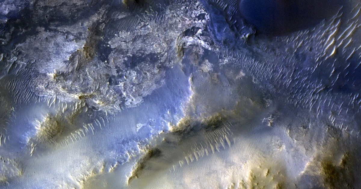
The milestone image, captured on October 7, 2025, provides a stunning look at a region known as Syrtis Major. This area is situated approximately 50 miles from the Jezero Crater—the current hunting ground for the Perseverance rover. The image itself is a tapestry of Martian complexity, showcasing a labyrinth of mesas and wind-sculpted dunes. At the high resolution provided by HiRISE, the surface reveals a mosaic of colors and textures that challenge the "Red Planet" moniker, displaying shades of basaltic blue, dusty ochre, and iron-rich crimson.
Perhaps the most significant aspect of this 100,000th image is its origin. It was not selected by a high-level NASA administrator or a senior planetary scientist. Instead, the target was suggested by a high school student through the "HiWish" program. This public-outreach initiative allows anyone—from professional researchers to curious students—to nominate specific coordinates on Mars for the HiRISE camera to photograph. By involving the public in the selection of the 100,000th image, NASA has underscored its commitment to democratizing space exploration, making the distant frontiers of our solar system accessible to the next generation of explorers.
Chronology: Two Decades of Orbital Excellence
The journey to 100,000 images began on August 12, 2005, when the MRO was launched atop an Atlas V rocket from Cape Canaveral, Florida. At the time, the mission’s primary objective was focused: "Follow the Water." Scientists wanted to determine if liquid water had persisted on the Martian surface long enough to support life.
The Arrival and Early Discoveries (2006–2010)
After a seven-month transit through deep space, MRO arrived at Mars in March 2006. It spent the next six months performing "aerobraking"—a delicate maneuver where the spacecraft dipped into the upper atmosphere to use friction to circularize its orbit. By November 2006, the primary science phase began. Almost immediately, HiRISE began sending back images of unprecedented clarity, revealing details as small as a kitchen table from an altitude of 150 to 200 miles.
The Middle Years: Monitoring a Changing World (2011–2020)
As the mission surpassed its original two-year lifespan, its focus shifted from static mapping to temporal monitoring. Scientists realized that MRO offered a unique opportunity to watch Mars change in real-time. Over this decade, HiRISE captured the movement of massive sand dunes, the appearance of new impact craters, and the seasonal "growth" of dark streaks on slopes, known as Recurring Slope Lineae (RSL), which sparked intense debate regarding the presence of contemporary briny water.
The Modern Era: Paving the Way for Humans (2021–Present)
In recent years, MRO has taken on a dual role. It continues its high-resolution science, but it also serves as a critical communications relay for the Curiosity and Perseverance rovers. Furthermore, it is the primary tool for landing site selection. Every rock and crater that the Perseverance rover traverses was first vetted by the "eye in the sky" provided by HiRISE. The 100,000th image represents the culmination of this twenty-year evolution from a scout to an indispensable infrastructure hub.
Supporting Data: The Power of HiRISE
The HiRISE camera is not a standard camera in any traditional sense. It is a 1.6-foot (0.5-meter) reflecting telescope, the largest ever carried on a deep-space mission. Operated by the University of Arizona in Tucson, the camera’s technical specifications are staggering:

- Resolution: HiRISE can resolve objects as small as 1 foot (30 centimeters) per pixel. This allows scientists to see individual boulders, cracks in the ice, and the tracks left behind by rovers.
- Data Volume: A single HiRISE image can be up to 28 gigabits in size. Processing these massive files requires significant computing power and a dedicated team of specialists to stitch together the "swaths" of data.
- Spectral Range: While many images are released in black and white to maximize resolution, HiRISE also captures data in near-infrared and blue-green spectrums, allowing scientists to identify different minerals and soil compositions based on their "color" signatures.
Beyond the camera itself, the MRO spacecraft carries five other instruments, including the CRISM spectrometer for mineral mapping and the SHARAD ground-penetrating radar. Together, these tools have allowed MRO to map the subsurface ice deposits that will be vital for future human colonists.
Official Responses: Insights from the Mission Team
The milestone has been met with reflection and pride by the teams at NASA’s Jet Propulsion Laboratory (JPL) and the University of Arizona.
Leslie Tamppari, the MRO project scientist at JPL, emphasized the transformative nature of the mission’s longevity. "HiRISE hasn’t just discovered how different the Martian surface is from Earth, it’s also shown us how that surface changes over time," Tamppari stated. "We’ve seen dune fields marching along with the wind and avalanches careening down steep slopes. We used to think of Mars as a fossilized world, but MRO proved it is very much alive, geologically speaking."
Shane Byrne, the principal investigator for the HiRISE camera at the University of Arizona, highlighted the importance of the public’s role in the mission. "Rapid data releases, as well as imaging targets suggested by the broader science community and public, have been a hallmark of HiRISE," Byrne noted. "One hundred thousand images just like this one have made Mars more familiar and accessible for everyone. It’s no longer a blurry dot in a telescope; it’s a place with geography we can name and weather we can predict."
Implications: The Road to Human Exploration
The 100,000 images captured by HiRISE serve a purpose far beyond academic curiosity. They are the foundational documents for the next great leap in human history: the crewed mission to Mars.
Landing Site Safety
Every future mission, whether robotic or human, relies on HiRISE data to ensure a safe landing. By analyzing the 100,000-image archive, NASA engineers can identify areas free of "spacecraft-eating" boulders or soft sand traps. The high-resolution imagery allows for the creation of 3D digital terrain models, which are programmed into the landing computers of modern spacecraft to facilitate "Terrain Relative Navigation."
Resource Identification
For humans to survive on Mars, they must "live off the land." MRO has been instrumental in identifying massive deposits of water ice buried just beneath the surface. HiRISE has even captured images of "fresh" impact craters that have excavated bright white ice, proving that life-sustaining resources are within reach of a simple shovel.
Understanding Planetary Evolution
By studying the 100,000th image and the 99,999 that preceded it, scientists are piecing together the story of planetary death. Why did Mars lose its atmosphere? How did a world with rushing rivers turn into a frozen desert? Understanding the fate of Mars provides crucial data points for understanding Earth’s own climate future and the habitability of exoplanets in distant star systems.
As the Mars Reconnaissance Orbiter continues its mission, its cameras remain pointed downward, ready for the next 100,000 frames. While the spacecraft is aging, its contributions remain timeless. It has turned the Red Planet into a familiar neighbor, a world of intricate beauty and untapped potential, waiting for the first human footsteps to match the tracks it has already mapped from the stars.


Leave a Comment